Stuff we have and use [and do...]

November 21, 2014

Taking communications for granted...

Ship-to-Shore Radio: A combination radio transmitter/receiver that permits captains and crew members to obtain wrong numbers and busy signals while at sea...  (Sailing Pocket Dictionary by Henry Beard & Roy McKie)
The last few days while working on our house in Fairbanks we have been reminded one can never take the internets for granted...

Since moving onto the boat this spring, we have been completely reliant of our AT&T smart phones for internet connectivity. The last 4 days in Fairbanks, the cell tower nearest our house has been dysfunctional as far as cell data is concerned. When we take our phones to town, everything works fine... [There is even LTE in town- which we don't get at home even when everything is working normally...]

Yesterday afternoon [Day 3 of the service disruption] I spent an hour on the phone with an eager and helpful AT&T tech who, among other things, reset cell tower connections to my phone several times- having me reboot my phone in between. But in the end, their efforts yielded no results. 

The tech then opened and escalated a trouble ticket. Here we are 24 hours later with no change.

My point is we cannot assume this stuff will work all of the time, giving us pause to reconsider reliance on a single source [if it is a critical service...] In this case, right now it hasn't worked for over 13% of the current billing period... Do you suppose they will see fit to apply that percentage discount to the data portion of our next bill?... I mean, when your power goes out...

[Update: This AT&T outage lasted 15 days, or 50% of our billing period...]

On the other hand, perhaps AT&T is doing us a favor... It is easy to become dependent upon the internet and ignore other means of communication, or life in general...

I lament at the state of our media choices: we started with smoke signals and drums, advanced to morse code, then teletype. Next came voice, then video calls...  Cool. Now, as a culture, we have digressed back to teletype (text messaging…) as our communication method of choice… At least the terminals are compact and portable...

Some of you may be wondering how we posted this if we have no internet connectivity... good catch! 

Using our trusty UUplus eMail service (for the bandwidth challenged...) we have squeaked through some emails on the rare intervals of Edge cell data service being available. [We have seen blazing network speeds of up to 10.4 KB/second... Hey, that's 4 times faster than our sat phone and doesn't cost $1/minute...] Our blog is set up to auto-publish emails we send to a special address... Just because we are in the dark, and can't even see our own blog, doesn't mean you should be... After all, this is how it will be when we are at sea… Practice...

For this privilege of being able to communicate using our chosen methods, we spend several hundred dollars a month [cell, sat, and UUplus plan. Thankfully other email and blogs are free...] All this just so we can send an occasional [plain text] eMail and photo? [And do our banking, purchasing, research, etc…] 

We may have to re-evaluate our budget priorities in the future and consider a further digression- perhaps this time to smoke signals… or perhaps one of the more labor intensive but free HAM radio email services...
--

November 11, 2014

Boat Solarium

Those of you in warm climates may not be able to relate, but ask me how I feel about our boat's solarium... [pilot house...] I am sitting here finishing my morning coffee, listening to water drip on the deck from the frost melting in the rigging... Just another sunny autumn day in Wrangell Alaska... [See our How's the Climate post...]


Bill basking in sunlight  in pilothouse

November 10, 2014

Keeping the rain out

This post has been added to our sidebar:

Stuff we have and use [and do...]

Please go to that page to see the most recent information (especially references) as this post will become out-of-date over time...

____________________________

Original blog post from 10-Nov-2014:

We choose to live in a temperate rainforest climate for now, and consequently we need to keep water out while we let air in.

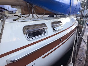
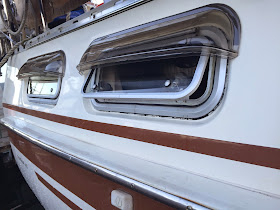
Our aft cabin [where we sleep] has 4 opening ports [as well as 2 fixed ports on the transom and a hatch overhead.] 

It is worth noting our ports are recessed into the cabin sides, and open outward. Therefore they are pretty good at keeping light rain out already...
However, both of these attributes are somewhat unusual; typically ports open toward the inside of the boat. 
I mention this because we had to be extra careful double-checking dimensions of the PortVisors to make sure we could still open the port, and that the drip line of the PortVisor didn't cause any spattering into the open port...
We were lucky enough to find an off-the-shelf product that fit our needs [and ports...] perfectly: Seaworthy Goods PortVisor® [model 23-R.] These units are thermal molded Lexan with UV inhibitors and consequently are very durable, flexible and virtually unbreakable... And the company is very responsive and great to do business with.

Here are 5 photos that are pretty self explanatory... [See the SeaworthyGoods.com website for product details and FAQs...] 


Dry fitting lexan port visor
Dry fitting port visor
Dry fitting lexan port visor
The tape hinge worked perfectly for final positioning

Dry fitting lexan port visor
Showing the open port in its normal latched position [they lock open in this position]
(The drip line just hits lower portion of port, but water does not splash into opening...)
Port visor install completed
Starboard side complete! (Looking forward)

Port visor install completed
Looking aft 
(The black around the port frame is bedding compound which was once painted white for UV protection...)


November 9, 2014

Siren Marine Boat Monitoring System [Updated Dec-2020]

For those of you interested in our Anchor Watch methods/apps, please also read our related post Sleeping Well at Anchor...

____________________________________


Preface to the subject post [below]:


We first went live with Siren Marine in 2014 with their original 2G monitoring device. But 2G cell service was depricated nearly worldwide by 2017, so our original device is no longer working... 

In late 2017 Siren Marine launched the next generation of their boat monitoring system. Their new MTC device uses 3G cell data [instead of the now depricated 2G their original device used, and we installed as discussed below...] 

However,  cell service providers are setting dates for ending 3G service... [e.g., Verizon will shut down 3G the end of 2019; AT&T in early 2022...] so it sounds like future cellular based hardware will need to support 4G at a minimum [and hopefully satellite and WiFi...]

Rinse. Repeat. 

In late 2020, Siren released their next model; The Siren 3 Proand it is quite future-proofed [4G international cell service, and world-wide satellite coverage is an option.]

Their new Siren 3 Pro can also use wired or wireless sensors, and has what appears to be a much more elegant app and user interface for monitoring your vessel. 

We have not upgraded to the new hardware yet because we live on our boat full time these days. Therefore our need for a replacement vessel monitoring system is not as urgent...

Our original post [below] still applies with regards to how well we liked being able to monitor [and to some extent control] our vessel when away from it for brief or long periods of time. Therefore we are leaving it as written. Just be advised it discusses a now obsolete Siren model that used SMS messages for alerts [instead of the new app and web interfaces...] 

What would we choose if we needed a vessel monitoring system today?

We would give serious consideration to a Siren 3 Pro as a well supported, stand-alone unit and service— especially since we already have all the sensors we need with the original installation in 2014.  [These sensors are fully compatible with the new model...]

IF we needed a new AIS transponder with integrated Marine VHF radio [we don't...]  we would analyse the Vesper Marine Cortex system which includes vessel monitoring capabilities along with the AIS and VHF capabilities. 


____________________________________

Original Post from Nov-2014:

[Read How Siren Marine saved our bacon at the end of this post.]

I just completed the initial installation of the Siren Marine remote vessel monitoring system mentioned in my Putting her to bed for the winter... post.  

This device sends SMS messages to our cell phones [up to 4 phones or email addresses] based upon how we configure it (and we can make programming changes from our cell phones...) [The SIM card is international and is supposed to work in 160+ countries without us having to do anything except make sure our cell phones are working...]

Of course, it is only useful when it [and your mobile phone] has a cell signal. 

Using this device, we actively monitor: [24/7/365 when we have cell signals...]

  • Temperature inside the boat [Another probe can be added. e.g., for freezer, etc.]
  • Bilge pump cycles and duration
  • High water alarm (in bilge) [based upon sensor placement]
  • Intrusion detection 
    • We use motion detectors, but pressure mats, canvas snap switches, sliding hatch contacts, etc. are available. 
    • It can be a silent (SMS only) or local alarm siren
  • House battery bank voltage
    • we can set hi/lo notification thresholds
  • Shore power on or off [set to notify when it goes off; notifies again when on...]
  • Location
    • and it will notify us if the boat has moved, and track it if so
    • we set those parameters
  • Count down timer 
    • We connected to the engine oil pressure switch and set an alert at 100 hrs for oil change reminders
  • It also allows us to control 2 electrical circuits [AC or DC- via relay] remotely via cell phone
    • We separately control our deck lights and main cabin lights as we depart/approach the vessel. 
    • They shut off automatically after a user configurable period- currently 5 minutes.
  • Remote main battery bank switch
    • normally on
    • we can disconnect the main battery bank remotely
This, not unlike various aides to navigation, will provide feedback that will help give us peace of mind and allow us contact the local person who will be watching the boat should anything need immediate attention...

The unit is 3.xVDC  with an internal LIon battery. I ran it for 20 hours on the internal battery right out of the box before installing and connecting it to the boat's 12VDC battery bank. [Can also connect to 24 VDC] This test on internal battery included both GPS and cell. I made it report every hour, and requested many ad-hoc reports during this period as well. In a 20 hour period, the internal batt went from 100% to 39%.  

It will run a long time on the boat's 900AH battery bank.

Following are some actual reports as sent by the unit: (SMS to my cell phone- either on-demand or automatically based upon configurable reporting thresholds.)

Here is the standard signal strength report:
09:47 DENALI ROSE GETSIG: 311:370, GSM  SIGNAL:4 bars. SSI = 24, SSILMT = 5. GPS SIGNAL: FIX = 3 SAT = 11

And a position report: (You can also activate a geofence to report change in location. e.g., Anchor dragging, theft, etc...)
DENALI ROSE POS (NEW) Co 0, Sp 0 Kn,

Standard INFO report: [We programed unit to send twice daily...]
09:46 DENALI ROSE Backup batt % : 100 [the unit's internal battery]; Ext batt volt: 13.06 [ship's battery bank] DENALI ROSE Current temp 60.8F [inside boat temp], Highest recorded temp 68.0F, Lowest recorded temp 59.0F.
Bilge pump running alert: [I learned you can customize this text, so I did...]
DENALI ROSE PRIMARY BILGE PUMP RUNNING
DENALI ROSE PRIMARY BILGE PUMP OFF
Shore power: [Also customized text...]
DENALI ROSE SHORE POWER LOST! 
DENALI ROSE SHORE POWER OK
There are also motion sensors indicating when someone is onboard, a high water alert, etc. You get the idea.

So far everything works as expected.


The only minor anomaly so far is it does slightly under-report the ship's battery voltage (by about 0.15 to 0.2  volts) ["Ext batt volt" in INFO report, above] but as long as it is consistent I can live with that relative reading.

I can say that Siren Marine is excellent to work with and consistently very responsive. They seem to be actively innovating, so it will be interesting to see what they come up with in the future.


Disclaimer: We're just sharing how we spent our time and money, and why. We did not receive any compensation/incentive/special discounts from Siren Marine.  

Update: 16-Dec-2014
This unit has already paid for itself in the first month by literally saving our bacon (and other meat in the boat freezer...) [Remember we are away from the boat for the winter: 6-10 hours of airline commute time away (4 legs...) depending upon schedules.] 
The morning of 11-Dec-2014 our remote vessel monitoring system (SirenMarine.com Sprite) sent an SMS to our cell phones notifying us that shore power to the boat was off. [Several times within a 3 hour period.]  
(Murphy's Law mandates these things happen when you are away from the boat...)
We immediately contacted our caretaker who confirmed that power was on in the marina, and upon investigating determined that the 50 amp AC connection to the boat had failed. [Here is my post detailing what happened...] 
He was able to procure repair parts locally and replaced the faulty electrical fitting for us. [Thank you, Kim!]
Since it would have been 5 days from the time of this event until his next in-vessel inspection, our being immediately notified prevented several adverse consequences including a flat [and possibly damaged] battery bank, and subsequent loss of 3 months worth of provisions [meat] in the Engle freezer.
In addition, it helped us avoid the compounded risk of no bilge pumps [once the batteries went flat] not to mention the potential fire hazard of the live, arcing electrical inlet. 
This situation could have escalated quickly if it weren't for the Siren Sprite [and our extremely reliable and capable caretaker...]
_____

November 8, 2014

How's the Climate? [In Wrangell, Alaska...]

The following post was converted to a permanent and maintained page in our 
Stuff we have and use [and do...] sidebar on 19-Apr-2016.


Please go to that permanent page for up-to-date information.

_____________________________________________________________

Original Post:

Since we chose Wrangell Alaska as our home port, we are often asked by friends and family what the climate is like here. Generally, this is couched as concern for whether we like rain, since Southeast Alaska is part of the Pacific temperate rainforest... [We are asked lots of other questions about Alaska too...]

We are offered all kinds of feedback about how much it rains. Of course, before making a decision to migrate from the arctic to the rainforest, we did a bit of research, and found a great website for providing a lay overview to help answer such questions about climates:

Weatherspark.com (The nerdier amongst you may prefer www.climate.gov)

You can discover what we did and gain some additional insight about the climate-side of our choice by comparing other SE Alaska cities with Wrangell. (e.g., Ketchikan and Juneau)

Planning a visit and wonder how much you will need your heater? Explore the Heating Degree Days data for the area(s) you plan to visit. [The higher the number, the more you will run your heater...]

Was your climate a deciding factor for you? To put is all in perspective, look-up your climate data and compare that with your personal impressions... How objective were you?

And what about our water temperatures?

For current conditions and marine forecast, visit our Weather page.

Average Weather For Wrangell, Alaska, USA

Location

This report describes the typical weather at the Wrangell Airport (Wrangell, Alaska, United States) weather station over the course of an average year. It is based on the historical records from 1985 to 2012. Earlier records are either unavailable or unreliable.
Wrangell, Alaska has a humid continental climate with warm summers and no dry season. The area within 25 miles of this station is covered by forests (51%), tundra (25%), and oceans and seas (25%).

Temperature

Over the course of a year, the temperature typically varies from 29°F to 64°F and is rarely below 15°F or above 71°F.

Daily High and Low Temperature

The daily average low (blue) and high (red) temperature with percentile bands (inner band from 25th to 75th percentile, outer band from 10th to 90th percentile).
The warm season lasts from May 26 to September 9 with an average daily high temperature above 58°F. The hottest day of the year is August 6, with an average high of 64°F and low of 52°F.
The cold season lasts from November 13 to March 14 with an average daily high temperature below 41°F. The coldest day of the year is January 6, with an average low of 29°F and high of 35°F.

Fraction of Time Spent in Various Temperature Bands

The average fraction of time spent in various temperature bands: frigid (below 15°F), freezing (15°F to32°F), cold (32°F to 50°F), cool (50°F to 65°F), comfortable (65°F to 75°F), warm (75°F to 85°F), hot (85°F to 100°F) and sweltering (above 100°F).

Sun

The length of the day varies significantly over the course of the year. The shortest day is December 21with 6:51 hours of daylight; the longest day is June 20 with 17:43 hours of daylight.

Daily Hours of Daylight and Twilight

The number of hours during which the Sun is visible (black line), with various degrees of daylight, twilight, and night, indicated by the color bands. From bottom (most yellow) to top (most gray): full daylight, solar twilight (Sun is visible but less than 6° from the horizon), civil twilight (Sun is not visible but is less than 6° below the horizon), nautical twilight (Sun is between 6° and 12° below the horizon), astronomical twilight (Sun is between 12° and 18° below the horizon), and full night.
The earliest sunrise is at 3:58am on June 14 and the latest sunset is at 9:44pm on June 27. The latest sunrise is at 8:25am on December 26 and the earliest sunset is at 3:10pm on December 15.
Daylight savings time (DST) is observed in this location during 2012, starting in the spring on March 11and ending in the fall on November 4.

Daily Sunrise & Sunset with Twilight and Daylight Savings Time

The solar day over the course of the year 2012 . From bottom to top, the black lines are the previous solar midnight, sunrise, solar noon, sunset, and the next solar midnight. The day, twilights (solar, civil, nautical, and astronomical), and night are indicated by the color bands from yellow to gray. The transitions to and from daylight savings time are indicated by the "DST" labels.

Clouds

The median cloud cover is 98% (overcast) and does not vary substantially over the course of the year.

Median Cloud Cover

The median daily cloud cover (black line) with percentile bands (inner band from 40th to 60th percentile, outer band from 25th to 75th percentile).
On May 12, the clearest day of the year, the sky is clear, mostly clear, or partly cloudy 25% of the time, and overcast or mostly cloudy 57% of the time.
On October 16, the cloudiest day of the year, the sky is overcast, mostly cloudy, or partly cloudy 74% of the time, and clear or mostly clear 10% of the time.

Cloud Cover Types

The fraction of time spent in each of the five sky cover categories. From top (most blue) to bottom (most gray), the categories are clear, mostly clear, partly cloudy, mostly cloudy, and overcast. Pink indicates missing data. Outside of the United States clear skies are often reported ambiguously, leading them to be lumped in with the missing data.

Precipitation

The probability that precipitation will be observed at this location varies throughout the year. Precipitation is most likely around October 18, occurring in 28% of days. Precipitation is least likely around July 27, occurring in 16% of days.

Probability of Precipitation at Some Point in the Day

The fraction of days in which various types of precipitation are observed. If more than one type of precipitation is reported in a given day, the more severe precipitation is counted. For example, if light rain is observed in the same day as a thunderstorm, that day counts towards the thunderstorm totals. The order of severity is from the top down in this graph, with the most severe at the bottom.
Over the entire year, the most common forms of precipitation are light rain, moderate rain, drizzle, and light snow.
Light rain is the most severe precipitation observed during 52% of those days with precipitation. It is most likely around October 10, when it is observed during 16% of all days.
Moderate rain is the most severe precipitation observed during 19% of those days with precipitation. It is most likely around September 26, when it is observed during 7% of all days.
Drizzle is the most severe precipitation observed during 12% of those days with precipitation. It is most likely around November 9, when it is observed during 4% of all days.
Light snow is the most severe precipitation observed during 10% of those days with precipitation. It is most likely around January 8, when it is observed during 6% of all days.

Types of Precipitation Throughout the Year

Relative frequency of various types of precipitation over the course of a typical year.
During the warm season, which lasts from May 26 to September 9, there is a 18% average chance that precipitation will be observed at some point during a given day. When precipitation does occur it is most often in the form of light rain (61% of days with precipitation have at worst light rain), moderate rain (20%), and drizzle (17%).
During the cold season, which lasts from November 13 to March 14, there is a 23% average chance that precipitation will be observed at some point during a given day. When precipitation does occur it is most often in the form of light rain (41% of days with precipitation have at worst light rain), light snow (22%), moderate rain (16%), and moderate snow (13%).

Warm Season Precipitation

Cold Season Precipitation

Relative frequency of various types of precipitation during the warm and cold seasons respectively.

Snow

The likelihood of snow falling is highest around January 8, occurring in 10% of days.

Probability of Snow Fall Being Reported in a Given Day

Probability that snow will be reported at least once in a given day. The season is defined as the period during which the probability is greater than one third the maximum probability.
Either snow rarely accumulates at this location or snow depth measurements are unavailable or unreliable.

Humidity

The relative humidity typically ranges from 54% (mildly humid) to 95% (very humid) over the course of the year, rarely dropping below 32% (comfortable) and reaching as high as 100% (very humid).
The air is driest around May 1, at which time the relative humidity drops below 66% (mildly humid) three days out of four; it is most humid around September 22, exceeding 92% (very humid) three days out of four.

Relative Humidity

The average daily high (blue) and low (brown) relative humidity with percentile bands (inner bands from 25th to 75th percentile, outer bands from 10th to 90th percentile).

Dew Point

Dew point is often a better measure of how comfortable a person will find the weather than relative humidity because it more directly relates to whether perspiration will evaporate from the skin, thereby cooling the body. Lower dew points feel drier and higher dew points feel more humid.
Over the course of a year, the dew point typically varies from 22°F (dry) to 54°F (very comfortable) and is rarely below 4°F (dry) or above 57°F (comfortable).
The time of the year between June 27 and September 10 is the most comfortable, with dew points that are neither too dry nor too muggy.

Dew Point

The daily average low (blue) and high (red) dew point with percentile bands (inner band from 25th to 75th percentile, outer band from 10th to 90th percentile).

Wind

Over the course of the year typical wind speeds vary from 0 mph to 15 mph (calm to moderate breeze), rarely exceeding 24 mph (strong breeze).
The highest average wind speed of 9 mph (gentle breeze) occurs around December 27, at which time the average daily maximum wind speed is 15 mph (moderate breeze).
The lowest average wind speed of 4 mph (light breeze) occurs around July 22, at which time the average daily maximum wind speed is 9 mph (gentle breeze).

Wind Speed

The average daily minimum (red), maximum (green), and average (black) wind speed with percentile bands (inner band from 25th to 75th percentile, outer band from 10th to 90th percentile).
The wind is most often out of the south east (20% of the time) and east (19% of the time). The wind is least often out of the north east (2% of the time), south west (4% of the time), and south (5% of the time).

Wind Directions Over the Entire Year

The fraction of time spent with the wind blowing from the various directions over the entire year. Values do not sum to 100% because the wind direction is undefined when the wind speed is zero.

Fraction of Time Spent with Various Wind Directions

The fraction of time spent with the wind blowing from the various directions on a daily basis. Stacked values do not always sum to 100% because the wind direction is undefined when the wind speed is zero.